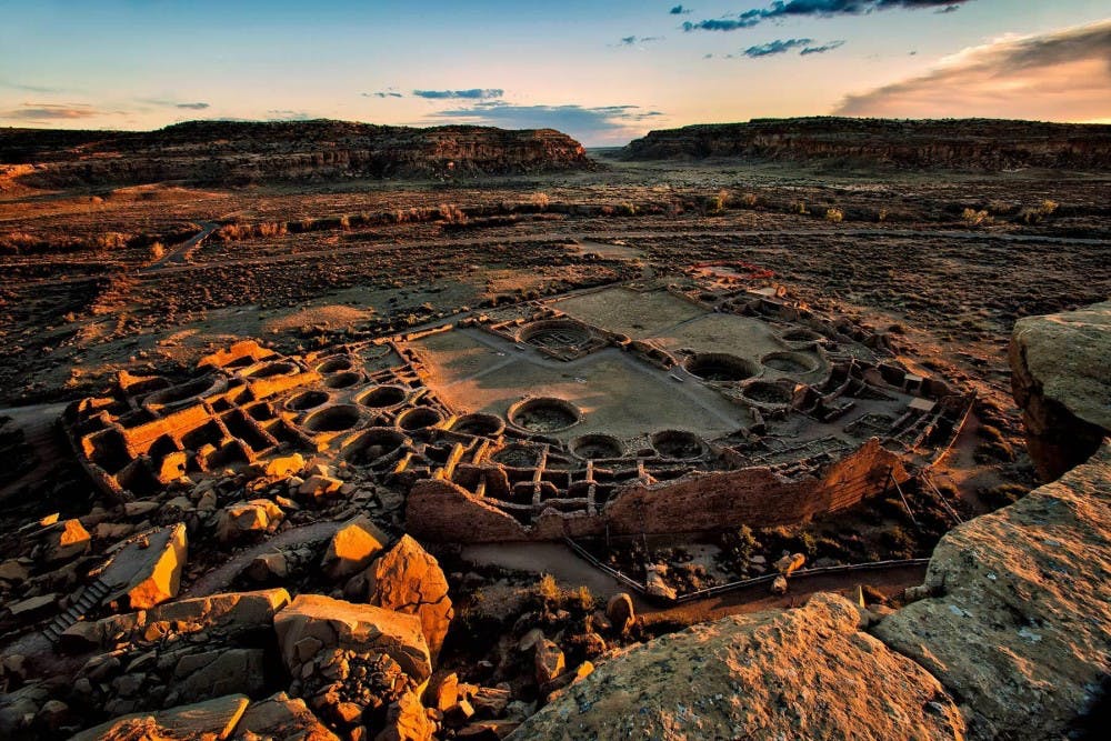
Chaco Canyon, New Mexico
From Places of Peace and Power website:
Deep in the remote deserts of northwestern New Mexico lie the extensive ruins of the greatest architectural achievement of the northern American Indians. Known as the Chaco Canyon complex, the site was the main social and ceremonial center of the Anasazi culture. We do not actually know what these people called themselves; the word Anasazi is a Navaho word meaning variously “the ancient ones” or “the enemies of our ancient fathers.” The early Anasazi (100 BC.) were nomadic hunter-gatherers ranging over great expanses of territory; by AD 700 they had begun to live in settled communities, of which Chaco Canyon is the finest example. Intensive construction occurred throughout Chaco Canyon from AD 900 to 1100, resulting in the development of several sophisticated dwelling complexes. Pueblo Bonito (meaning “pretty village” in Spanish; the original Anasazi name being unknown) had more than six hundred rooms, numerous two- and three-story buildings, several ceremonial structures called kivas, and a population between 800 and 1200 persons. From tree-ring dating, it is known that a period of great drought came upon the Chaco area in AD 1150, causing the abandonment of the site. Rediscovered in 1849 by U.S. Army soldiers, the site was severely vandalized for seventy years until it was made a national monument in 1907. In 1920, National Geographic Society began a thorough reconstruction of the site.
Radiating out from the Chaco complex are an enigmatic series of straight lines that extend ten to twenty miles into the desert. Conventional archaeological theories explain these lines as roads leading to outlying settlements, but this seems highly unlikely, as the lines are arrow straight regardless of terrain. They go over mesas (table-top mountains), up and down vertical cliff faces, and a long ways that make them utterly impractical for use by the casual or commercial traveler. Perhaps they had another purpose. Paul Devereux, a British scholar, and writer in the so-called “Earth Mysteries” field have suggested that these lines (and others he has studied around the world) are better understood as markings that represent the out-of-body spirit travels of ancient shamans. Archaeological research does indeed indicate that the lines often lead to small shrine-like structures where evidence of religious and shamanistic activity is common. These mysterious lines, sometimes apparently between no particular places, are found in many parts of the Anasazi region. More than five hundred miles of the lines have so far been charted. Nowadays they are mostly visible only from the air in the early morning or late afternoon when the sun casts deep shadows. Inspecting these lines at ground level, it is evident that they have been acted upon by many hundreds of years of natural erosion, which has obscured all but scarce remains. It, therefore, seems reasonable to suggest that these lines, prior to their erosion, could have been followed across great expanses of land, thereby delineating an enormous grid or map of sacred and shamanistic geography.
PHOTO CREDIT: ANDREW KEAMS/FLICKR
To read more about this fascinating place see:
https://sacredsites.com/americas/united_states/chaco_canyon.html